
Geographical Zones
In accordance with Article 15 of the Commission Implementing Regulation (EU) 2019/947, geographical zones for unmanned aircraft systems (UAS) are designated within Polish airspace.
What are geographical zones?
Every airspace has what are known as airspace structures— diverse types of zones designed to protect flights or activities that require segregation from other air traffic. The same applies in Poland. Initially, when drones (i.e., unmanned aircraft systems, or UAS) first appeared in the airspace, the flight rules applicable to manned aviation in specific zones also applied to unmanned aviation, i.e., these drones. Over time, as the number of drone flights grew rapidly, it became clear that it was not possible to apply the same airspace structures—and thus the same flight rules within a given zone—to both manned and unmanned aviation. Consequently, separate geographical zones were designated for unmanned aviation.
According to Commission Implementing Regulation (EU) 2019/947 of 24 May 2019, a geographical zone for unmanned aircraft systems refers to a portion of airspace designated by a competent authority, which facilitates, restricts, or excludes operations involving unmanned aircraft systems in order to mitigate risks related to safety, privacy, personal data protection, security, or the environment arising from such operations.
The concept of geographical zones had been also incorporated into Polish legislation, specifically in the Aviation Law Act under Article 119(1a) and Article 156h, as well as in the Act on the Polish Air Navigation Services Agency (PANSA), under Article 3a(1). This legislation designates PANSA as the competent authority responsible for establishing geographical zones, either on its own initiative or upon request from authorized entities.
Types of geographical zones

Visualisation of geographical zones in DroneMap.
Guidelines No. 4/2025 of the President of the Civil Aviation Authority of 21 February 2025nr 4/2025 on the designation of geographical zones for unmanned aircraft systems specify the following types of geographical zones designated by the Agency:
- DRA-P: A prohibited zone for unmanned aircraft systems, in which operations using unmanned aircraft systems may not be conducted, except for operations carried out by the Operational Commander of the Armed Forces, the Chief Commander of the Military Police, the Head of the Air Traffic Services Authority of the Polish Armed Forces, the Head of the Internal Security Agency, the Head of the Intelligence Agency, the Chief Commander of the Police, the Chief Commander of the Border Guard, the Chief Commander of the State Fire Service, the Head of the National Revenue Administration, the Head of the Central Anti-Corruption Bureau, the Commander of the State Protection Service, or the Chief Inspector of Environmental Protection — under conditions specified by the Agency.
- DRA-R: A restricted zone for unmanned aircraft systems, in which operations using unmanned aircraft systems are allowed to be conducted with the consent of and under conditions defined by the Agency or an authorized entity that requested the designation of the geographical zone.
The following types of DRA-R zones are distinguished:
-
- DRA-RH – a restricted zone with a high probability of obtaining consent for operations as mentioned above;
- DRA-RM – a restricted zone with a medium probability of obtaining consent for operations as mentioned above;
- DRA-RL – a restricted zone with a low probability of obtaining consent for operations as mentioned above;
- DRA-I: An informational zone for unmanned aircraft, containing information necessary to ensure the safe execution of operations using unmanned aircraft systems, including navigational warnings.
- DRA-T: A restricted zone for unmanned aircraft systems in which the Agency specifies technical requirements that the unmanned aircraft system used for operations in the zone must meet. A requirement to obtain consent for operations may also be imposed in a DRA-T zone.
Note: These geographical zones apply exclusively to operations performed using unmanned aircraft systems (UAS).
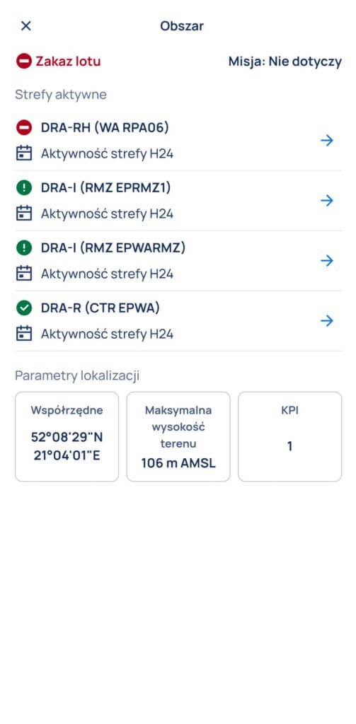
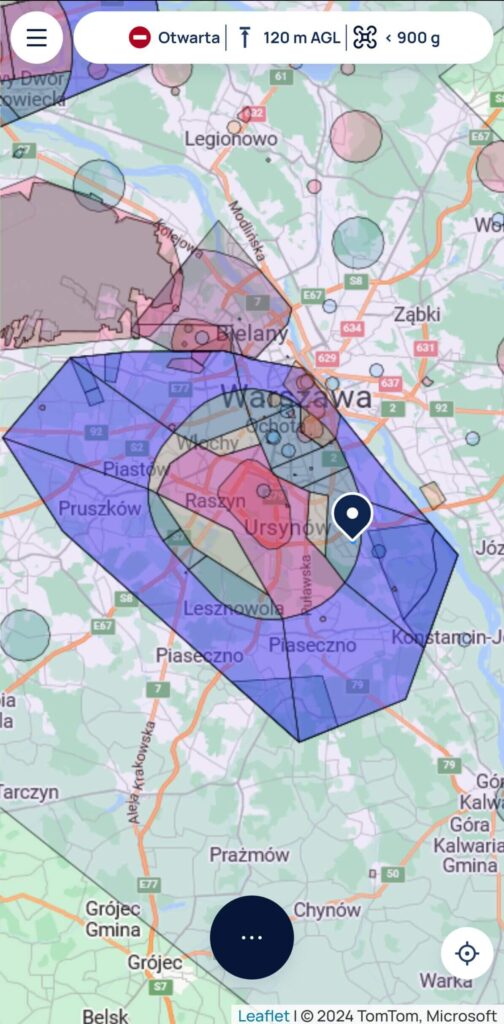
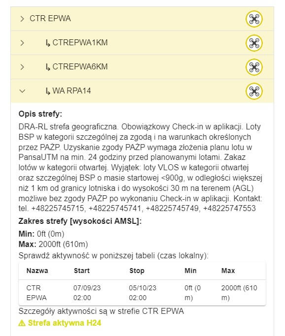
Information about zones in a given location, as displayed in the DroneTower app
Airspace Structures vs. Geographical Zones
Geographical zones are the equivalent of the airspace structures used in manned aviation (such as CTR, MCTR, ATZ, TRA, TSA, R, P, D, etc.) published in the Aeronautical Information Publication (AIP Poland) and define the rules for conducting UAS operations within them.
Geographical zones include flight restriction areas introduced for manned aviation via NOTAM messages.
The above restrictions and airspace elements are visible to UAS pilots in the PansaUTM system and in the DroneTower mobile application.
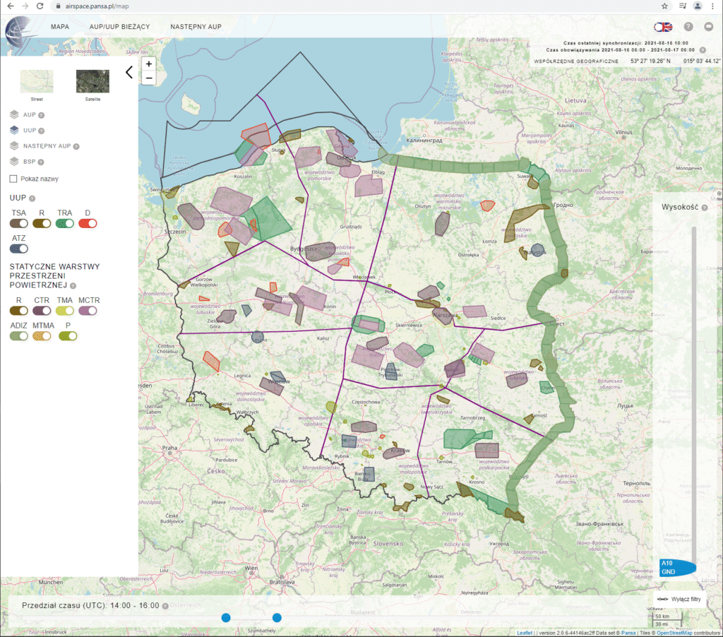
This is a graphical representation of the use of Polish airspace for manned aviation. It displays the reservations for airspace segments that are in force on a given day, at a given time and within a given altitude range. (airspace.pansa.pl/map).
The Agency is authorized to update designated geographical zones, particularly regarding the definition of new zone boundaries, conditions for conducting operations within a geographical zone, or the period of its applicability.
Rules for Flights in Geographical Zones
Operations using UAS must be conducted in accordance with the rules defined for a given zone and after notifying PANSA services of the intention to perform a flight—this means submitting a flight notification via the DroneTower mobile application.
In some cases, it is necessary to submit a flight plan in advance via the KISD Mission Planner
and obtain its approval by PANSA. This applies to i.e., DRA-R geographical zones around controlled airports (CTR).
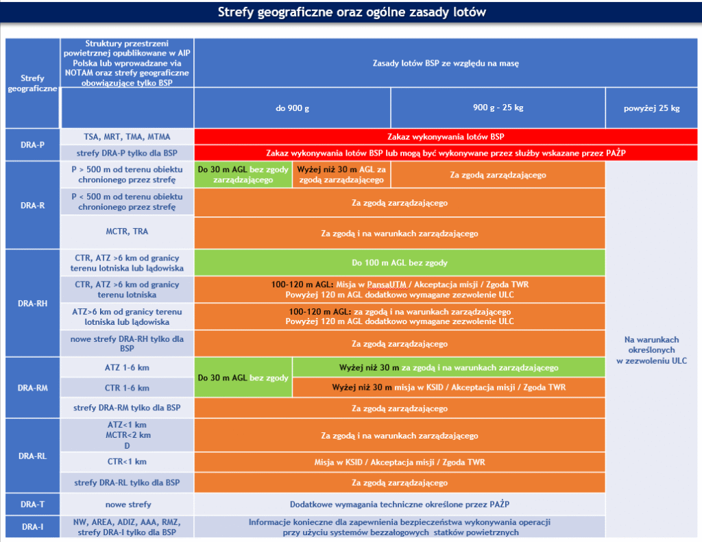
The previous rules for flights within converted airspace elements, in accordance with regulations issued under Article 121(5) of the Aviation Law, are presented in the table below.
These rules may change over time, as according to Article 156b (3) of the Aviation Law, entities for whom a given airspace structure element has been established may submit a request to PANSA for determining conditions for conducting operations using UAS.
Before each flight, a UAS pilot can check the DroneTower mobile application or the DroneMap
website to see which geographical zones are present in any location in Poland and to learn about the applicable restrictions, which said pilot is obliged to follow.
In the case of flights within geographical zones, in many instances, a flight will only be possible after obtaining consent from the zone manager.
In DRA-R zones located within controlled airspace of commercial airports (CTR), it is required to obtain approval from PANSA (except for the exceptions listed in the table above) by submitting a flight plan in PansaUTM at least 24 hours before the planned flight.
Legal basis
COMMISSION IMPLEMENTING REGULATION (EU) 2019/947 of 24 May 2019 (consolidated version as of 4 April 2022) on the rules and procedures for the operation of unmanned aircraft;
COMMISSION DELEGATED REGULATION (EU) 2019/945 of 12 March 2019 (consolidated version as of 9 August 2020) on unmanned aircraft systems and on third-country operators of unmanned aircraft systems;
Aviation Law Act of 3 July 2002 (Journal of Laws of 2023, item 2110; of 2024, items 731 and 1222; and of 2025, items 31 and 179);
Act of 8 December 2006 on the Polish Air Navigation Services Agency (Journal of Laws of 2024, item 1272; and of 2025, item 179);
Guideline No. 7/2024 of the President of the Civil Aviation Authority of 20 May 2024 on the procedures for conducting operations using unmanned aircraft systems in connection with the entry into force of Commission Implementing Regulation (EU) 2019/947 of 24 May 2019 on the rules and procedures for the operation of unmanned aircraft;
Guideline No. 4/2025 of the President of the Civil Aviation Authority of 21 February 2025 on the designation of geographical zones for unmanned aircraft systems.